The challenge of maintaining harbours and ports while conserving and sustaining coastal habitats, with all the rich resources they provide, requires that port and harbours do more to develop approaches to maintenance dredging that provide benefit to these neighbouring habitats. In this article, we describe an example from Harwich Harbour in the UK where Harwich Haven Authority (the Conservancy Authority) is looking to move to a more nature-based maintenance dredging methodology, using agitation dredging. Using the results of monitoring and sophisticated numerical modelling, we evaluate the likely benefit to the Stour/Orwell intertidal areas arising from the use of the agitation dredging.

Throughout the world, many ports and harbours lie adjacent to ecologically important areas of coastal habitat, providing valuable ecosystem services. These include: highly productive areas feeding large numbers of predatory birds; feeding, spawning and nursery areas for fish populations; absorption of nutrients and improving water quality; protection of the coast from flooding and erosion; efficient carbon sinks, contributing significantly to the sequestration of global carbon dioxide and provision of livelihoods to communities from shellfisheries to tourist industries. The deepened areas of these approaches and berths of these ports and harbours are often associated with siltation, maintenance dredging and offshore disposal away from the coastal system where the dredging takes place. In the UK, 40-50 million cubic metres (Mm3) of maintenance dredging is undertaken every year (Ausden et al., 2018). While some of this maintenance material is placed at licensed disposal sites within estuary systems, most of this material is placed offshore at licenced disposal sites and only around 1% is used to recharge and restore coastal habitats (Ausden et al., 2018).

The deposition and consequent removal of sediment from the maintained areas of ports and harbours can reduce sediment supply, which may result in long-term impacts resulting from depletion of sediment within a coastal system (e.g. Spearman et al., 2014). Even where offshore disposal does not adversely influence the coastal system, there is now a growing international consensus that maintenance material is a resource that can and should be used to promote sustainability of coastlines given the global threat of climate change and sea level rise. This consensus is manifested by the wealth of initiatives to align coastal development with nature, often expressed as “Engineering with Nature” (https://ewn.erdc.dren.mil) or “Building with Nature” (https://building-with-nature.eu), and the growth in beneficial use of dredged material (for instance around 30% of all dredged material in the US, Gailani, 2019). More recently, the sediment management pledge issued jointly by NavClimate, PIANC and the SEDNET network (SEDNET, 2021) during COP26, has resulted in a body of ports, stakeholders, engineering contractors and consultants committing to capitalise on the use of sediment for promoting nature, reducing emissions and exploiting sediment’s carbon storage properties.

COP26 sediment management goals

The COP26 sediment management pledge builds on ideas that have been developing for some time (e.g. IADC 2009, OSPAR 2014; CEDA, 2019). The idea is that more critical thinking about port management of dredging, building in consideration of ecology (in its own right) and the positive influence of ecology on coastal defence, can result in a win-win of minimising the overall costs of development to both nature and human society. When the economic importance of these wider considerations are included in decisions about development, the optimal options are often much more “nature-orientated” (Bridges et al., 2015; Laboyrie et al., 2018).

The COP26 sediment management goals highlight the need to promote, where possible, the restoration and creation of habitat, especially those leading to coastal resilience, noting that it is these same habitats that act as a valuable carbon store; and secondly they highlight a commitment to reducing the energy expended in the management of safe navigation. These goals infer a natural pattern of progress, where ports move from traditional approaches to maintenance dredging without consideration of maintenance material as a resource; to a more enlightened position where traditional maintenance operations are accompanied by beneficial use wherever feasible. Therefore moving to a position where the maintenance operations themselves are designed to maximise benefits for nature (and by extension coastal defence) while minimising use of CO2. This progression will take time as knowledge is gained and the needs of opposing stakeholders are reconciled and not every port will be able to progress fully along this path. While all ports will have scope to improve, some may be constrained to some extent by their environments, significant economic considerations or particular stakeholder concerns.

The COP26 sediment management goals highlight the need to promote the restoration and creation of habitat.

Case study

This case study is about the Stour/Orwell estuary system in the UK where the conservancy authority is looking to move to a more nature-based and low-carbon maintenance dredging methodology, using agitation dredging. Using the results of monitoring as well as sophisticated and well-validated numerical modelling, we evaluate the effectiveness of the agitation dredging methodology and the likely benefit to the intertidal areas of the Stour/Orwell system through its use.

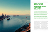
The Stour/Orwell estuary system

Figure 1 shows the Stour/Orwell system. The estuary system has a low fluvial input – the mean total fluvial discharge into the Stour and Orwell Estuaries is less than 5 cubic metre per second (m3/s), based on Environment Agency data and the UK National River Flow Archive. The tidal range is meso-tidal (3.6 metres (m) mean spring tidal range at the estuary mouth). Waves inside the estuary system are locally wind-generated (Spearman et al., 2014) although within Harwich Harbour (which is the name given to the confluence of the Stour and Orwell Estuaries, at the estuary mouth) swell waves propagate from offshore. Typical wave heights are 0.2 - 0.3 m in the Stour and 0.1-0.2m in the Orwell (HR Wallingford, 1994). However, during strong westerly winds, waves can rise up to 1 m throughout much of the Stour Estuary. Waves in the Orwell Estuary are generally lower because of the reduced fetch lengths (Spearman et al., 2014).

Figure 1

Stour/Orwell estuary system.

Figure 2

Mark IV Tiamat®.

On the east side of Harwich Harbour lies the Port of Felixstowe, the largest container port within the UK. Harwich Haven Authority (HHA) annually undertakes maintenance dredging of 2.4 Mm3 per year of soft mud (HR Wallingford, 2019). Historically, the mud was principally dredged by a trailer suction hopper dredger (TSHD), aided by plough dredging in the berths. All the material was, until recently, disposed around 30 kilometres (km) offshore of the estuary entrance at the Inner Gabbard disposal site. The sediment supplied to the estuary is almost entirely from offshore marine sources and predominantly enters from the near-shore zone north of the entrance along the Suffolk Coast (Spearman et al., 2014). The Stour and Orwell Estuaries have extensive mud flats that are protected (Special Protected Area/Ramsar status) because they support internationally important populations of migratory bird species: common redshank, dark-bellied brent goose, northern pintail, grey plover, red knot, dunlin and black-tailed godwit as well as a variety of nationally important species (JNCC, 2008).

The proposed change of dredging methodology

Prior to 1998, occasional small amounts of dredged material were used for direct beneficial use placements to facilitate habitat creation in Hamford Water, a wetland area located south west of the Stour/Orwell system. From 1998 to the present day, around 4% or more than 50,000 tonnes dry solids/ year (TDS/year) of the sediment dredged from Harwich Harbour has been dredged using a small TSHD of around 1,500 cubic metres (m3) capacity. This dredged sediment has been used for sediment recycling (also known as non-direct beneficial use or strategic placement), slowly releasing the sediment into the water column on the flood tide, in the Lower Stour Estuary and the Lower Orwell Estuary (Spearman et al., 2014).

This sediment recycling has been shown to be effective in increasing the area of intertidal habitat, particularly in more quiescent areas in the Upper Stour Estuary (Spearman and Benson, 2023). However, the current dredging methodology is not optimal because the vast majority of the material dredged from the harbour is still disposed offshore. Typically, the size of TSHD normally used for maintenance varies between 6,000 m3 and 16,000 m3 and the dredging cycle is around 4 hours. This includes around 40 minutes of dredging (with minimal overflow), the remainder being travel time to and from the disposal site that is located around 30 km offshore (based on information provided by HHA).

HHA is seeking to move to a more naturefocused agitation dredging methodology, for which it has given the term Dredging with Nature®. The proposed agitation dredging involves the resuspension of all of the material that settles in the deep-water harbour into the water column so that tidal currents within the estuary can transport it away from the dredging areas. The intention is that on the flood tide some of this resuspended sediment, just like the sediment recycling that is practised currently, will feed the intertidal areas of the estuary system, and which are considered to have been depleted by harbour deepening over the years (Spearman et al., 2014). The new methodology takes this idea to the next level, potentially mobilising greater volumes of sediment and removing the need for either offshore disposal or for the additional sediment recycling using a small dredge plant.

The overall concept for this agitation dredging is that the smaller dredger operates with lower instantaneous production rates (while still maintaining an overall production rate comparable with appropriately-sized TSHDs), requiring more frequent dredging and a semi-continuous release of (previously deposited) sediment into the water column to be carried away from the harbour by tidal currents. As such, the methodology is considerably closer to what would be the natural state of the estuary without deepening when sediment temporarily depositing at slack tide would be resuspended as currents pick up and be carried upstream to replenish intertidal flats or offshore depending on the tidal state. This approach therefore represents a step-change in nature-based dredging (Spearman and Benson, 2022).

The agitation dredging is proposed using a new type of dredger called the Tiamat® (Figure 2). The Tiamat® has been patented by HHA and developed by HHA in collaboration with Martens en Van Oord. Essentially the Tiamat® is similar to a water injection dredger (WID) design, in that it uses high- pressure water jets to inject water into the bed. However, rather than using the water jets to create a highly concentrated near-bed sediment layer that flows downslope under its own weight, as occurs with WID, the intention with the new dredger is to resuspend the sediment so that can be carried away by tidal currents. The design includes a release pipe at 6 m above the bed to encourage the dispersion of the sediment. The Tiamat® is designed to be towed by a tug or workhorse port vessel and is not self-propelling.

The methodology is considerably closer to what would be the natural state of the estuary without deepening.

Method

Overview

This study focused on evaluating the potential benefits (the extent to which deposition of sediment on intertidal areas was enhanced) as well as potential disbenefits (the extent to which suspended sediment concentrations within the estuary system were increased) as a result of the agitation dredging. The study made use of long-term surveying monitoring, monitoring of bed levels, density profiles and plume measurements associated with the October 2020 agitation dredging trial and numerical modelling using a detailed and well-validated 3D morphological model.

This combination of monitoring and modelling was developed (Spearman and Benson, 2023) to identify the changes in morphology resulting from sediment recycling. The use of agitation dredging to promote estuary benefit is analogous to non-direct beneficial use and so the method is also effective for the present study. The important aspect of the methodology is that it allows the effects of the non-direct placement (or this case agitation dredging) to be differentiated from background sedimentation effects. Baptist et al. (2019), for instance, found that the greatest rates of accretion during the placement associated with the Mud Motor (a pilot programme of monitored non-direct beneficial use undertaken in the Wadden Sea in the Netherlands, 2016-2017) were found during a period of reduced rate of placement and a direct link between beneficial placement and intertidal sedimentation could not be made (Baptist et al, 2019).

Trial monitoring – bathymetric change in the dredging areas

HHA measured the changes in bed level on eight occasions over the period 30 September to 20 November 2020. The areas that were dredged and surveyed during this period are shown in Figure 3.

Figure 3

Areas dredged during the trial. Titan Environmental Surveys Ltd., 2020.

The measured changes in the total volume of sediment in the surveyed areas is summarised as follows: The total background daily rate of accretion in the four dredge areas through the monitored period varied between 5,046 m3/day (30 September to 19 October) and 2,486 m3/day (10 November to 20 November) or 3,766 m3/day on average. The net production rate of the dredger, as calculated from the lowering of the bed over the period 30 October to 10 November was 2,544 m3/day. This is the change in volume that is observed but in reality while the dredging is removing sediment from the bed more sediment is depositing and this net rate is a combination of both.

This approach therefore represents a step-change in nature-based dredging.

The actual production rate of the dredger is the net production rate plus the average background rate, 5,030-7,590 m3/day or 6,310 m3/day on average.

The average production rate (measured by volume) is much smaller than the equivalent production rate measured in tonnes dry solids (TDS). This is because the multi-beam sensor used to measure the bed level was detecting the low-density material at the sedimentwater interface, which only experienced relatively minor change during the dredging.

Trial monitoring – density profiling

HHA measured the changes in density of the seabed at 22 locations throughout the dredging areas on nine occasions over the period 12 October to 23 November 2020. The measured changes in density are summarised in Figure 4 by averaging the elevations for each density profile for all locations for each day of measurements. The results shown in the figure can be integrated through the bed profile to get the (average) variation in mass above the maximum density contour (here assumed to represent a bulk density of approximately 1,400 kg/m3, or a dry density of around 600 kg/m3). This maximum density contour is broadly constant in position so the change in mass above it represents the effects of dredging in removal of sediment from the bed.

Figure 4

Measured depth below Chart Datum of bed density over time (averaged across all measurements).

The difference in the mass in the bed at the start of dredging and the end of dredging is 352 kg/m2, which is an average over the (approximately) 780,000 m2 total area of dredging. Over the period of dredging, this is equivalent to 9,803 Tonnes Dry Solids (TDS) per day (TDS/day). On the basis that the sediment removed from the bed is released into the water column, the release of 9,803 TDS/day is equivalent to 320 kg/s (for the 8.5 hours of daily dredging operations). Roughly, 10% of the bed is sand, which will quickly redeposit on the bed, so that the release of fine sediment (silt/clay) into the water column is 288 kg/s. This average release rate during dredging is used for both the plume and morphological modelling. It is worth noting that this dredging rate is equivalent to 4,150 TDS over 4 hours (the typical dredging cycle of a TSHD dredger, based on HHA data). This productivity rate is similar to a typical TSHD productivity for a 9,000-m3 TSHD of 4000-4500 TDS per cycle (based on HHA data).

Net productivity was equivalent to a medium-sized TSHD but at a reduced economic and energy cost.

Measurements of dredging plume concentration increases

The plumes from the Tiamat® dredger were monitored on the 24 October and 26 October during neap tide conditions. The 24 October measurements were undertaken during three different ebb, low water (LW) and flood conditions during dredging in Dredge Area 2. The 26 October measurements were undertaken during high water (HW), ebb and LW conditions during dredging in Dredge Area 3. The plumes were measured for suspended sediment concentration using a combination of water sampling, profiling of suspended sediment concentrations using a calibrated turbidity sensor and vessel-mounted ADCP transects across the plume. These latter transects measured velocity and backscatter, and were calibrated using the SEDIVIEW software (Wither et al., 1998; Land and Jones, 2001) to provide suspended sediment concentrations and flux using the water samples and profiling data (Titan, 2020a). The background sediment flux through each plume transect was estimated based on the measured concentrations either side of the plume and subtracted from this total sediment flux, to produce the excess sediment flux associated with each transect. These estimates of excess sediment flux were then corrected in two ways:

  1. Some of the transects were affected by wakes from the tug towing the dredger. Affected “ensembles” in the ADCP output were removed and replaced with the fluxes from adjacent ensembles.
  2. The excess sediment flux represents the rate of release of fine sediment that would be necessary from a stationary vessel to produce the same plume. However, as the fine sediment creating the plume is released from a moving vessel, the measured flux needs to be corrected to account for the motion. For this reason, the sediment flux is adjusted by the factor (van Maren et al., 2009):

Overall, the measured plume fluxes varied from 2 kg/s to 1,373 kg/s with an average flux of 427 kg/s. This estimated flux represents the flux of fine sediment (only) disturbed by the dredger. The dredging logs provided by HHA indicate an average of around 8.5 hours of dredging per day. The corresponding changes in bed mass (from Figure 4) over the specific period 23-26 October are equivalent to a release of fine sediment of 512 kg/s, which is of a similar magnitude to the measured release rate of 427 kg/s derived from the SEDIVIEW measurements.

Figure 5

Model domain and mesh, showing locations of Admiralty tidal stations used.

Figure 5

Model geometry and mesh within Harwich Harbour.

Table 1

Morphological wind and wave conditions.

Modelling

Flow model set up

The TELEMAC-3D code (http://docs. opentelemac.org) is a finite-element model, which solves the 3D free surface flow equations (with or without the hydrostatic pressure assumption) and the transportdiffusion equations of intrinsic quantities (such as temperature, salinity, tracer concentration). The TELEMAC-3D code uses an unstructured mesh made of triangular prisms and the vertical includes both sigma and flat layering as well as generalised layering. Figure 5 shows the model domain and mesh used in the present study. The resolution of the mesh is coarsest in the middle of the domain, away from coastal boundaries, with an element size of about 5 km, reducing to 40 m or finer inside the harbour (Figure 6). Resolution within the Stour and Orwell Estuaries was set to approximately 80 m or finer. The flow model was driven on the boundaries of the model using predicted tides for a spring-neap cycle provided by the Admiralty’s TotalTide© software. A total of eight tidal station locations were used (labelled in Figure 5) and the levels between each tidal station were linearly interpolated along the length of each of the tidal boundaries. As the freshwater flow input to the Stour and Orwell Estuaries is generally very low, no freshwater runoff was included in the model.

Wave model setup

The wave model SWAN was used to consider the processes of wave generation by local wind conditions and wave transformation. SWAN (https://swanmodel.sourceforge.io) is a third generation spectral wave model, which simulates the transformation of random directional waves including: wave shoaling; wave refraction; depth-induced breaking, bottom friction and white capping; wave growth due to wind; wave reflections from structures or rocky shorelines; and far-field wave diffraction. The SWAN model was configured so that the model mesh was identical to the TELEMAC-3D mesh and was driven by application of wave conditions to the offshore boundaries of the model and by a spatially varying wind over the model domain. Wind data were obtained from Met Éireann’s MÉRA reanalysis (Gleeson et al., 2017; Whelan et al., 2018) for a point offshore from Felixstowe at 51.9°N 1.328°E. These wind conditions were analysed to derive representative wind conditions for eight direction sectors. The spatial variability of the wind was modelled using the WAsP model (Mortensen et al., 2001). Offshore wave conditions were derived from the ERA5 global wave hindcast produced by the European Centre for Medium-range Weather Forecasting (ECMWF). Wave conditions were associated with the wind conditions from MÉRA by correlation by direction sector.

The variation in wave direction, size and period was characterised into eight “representative” waves that represent the “average” wave from each of eight different directions (as shown in Figure 8). “Average” here means the wave whose contribution to fine sediment transport corresponds to the mean transport across the whole range of wave conditions experienced from this direction. These representative waves are sometimes referred to as “morphological” waves and the methodology used to derive the representative wave is described in Chesher and Miles (1992). The representative or “morphological” waves are presented in Table 1. For each wave simulation in the morphological model, the water levels within the SWAN wave model were varied according to the water level predicted by the flow model. This allowed the effects of the reduced fetch and reduced water depth resulting from low water, and the resulting reduction in wave action, to be represented within the morphological model.

Sediment transport model

The sediment transport model used in this study was the TELEMAC-3D model, i.e., the same model as the flow model. This enables the sediment and flow to be fully coupled and able to influence each other at the time-step level. Settling of the suspended mud was parameterised using a constant settling velocity of 1.5 mm/s. At high concentrations, the density of the suspended mud in suspension becomes sufficient to cause some stratification of the density of water through the water column resulting in damping of the vertical mixing and potential increases in the near-bed concentrations. This mechanism is included in the model using the formulation of Munk and Anderson (1948).

The modelling methodology allows the effects of the agitation dredging to be differentiated from background sedimentation effects.

A two-layer bed model was used for modelling the bed exchange processes in the model. In the bed model, the uppermost sediment layer represents mobile material that is readily eroded each tide by the combined action of currents and waves then transported by the flows and deposited again around the time of slack water. Net erosion or deposition occurs in the model depending on the balance between erosion flux from the bed and the deposition flux. Deposition of sediment from the water column is assumed to occur continuously into the top sediment layer at a rate equal to the product of the settling velocity and the near bed suspended concentration. For the top bed layer, a critical shear stress for erosion of 0.2 newtonnes per square metre (N/m2) was set everywhere. When this threshold is exceeded by the combined effect of waves and currents (Soulsby and Clarke, 2005), erosion is initiated and material erodes from the top bed layer at a rate predefined by the erosion rate constant (Partheniades, 1965). In this case, the erosion rate constant was set to the value of 0.001 kg/m2/s. This value is within the range used by other researchers generally found in the literature (Whitehouse et al., 2000).

The underlying bed layer represents the in situ sediment that has experienced previous consolidation or is mixed into the pore spaces of coarser grained material. The critical shear stress for erosion for this layer was parameterised with spatially varied values (for details see Spearman and Benson, 2023). The erosion rate for the lower bed layer was calibrated to be 5x10⁻⁵ kg/m2/s. The dry density for the lower layer was set to 750 kg/m3 (bulk density of approx. 1470 kg/m3). The effect of consolidation of freshly deposited material may affect the distribution of erosion and deposition within the estuary system. In addition, within the estuaries, there can be biological processes (biofilms and other biogenic extracellular polymers) that act to prevent sediment from being resuspended. These consolidation and biological influences are indirectly represented by the parameter settings used but are not explicitly represented in the model.

The sediment transport model was validated against sediment flux measurements collected during surveys commissioned by HHA in February 2001 during a set of spring tides (HR Wallingford, 2001) and more recent, surveys on 21 October 2020 (spring tide conditions) and 25 October 2020 (neap tide conditions) (HR Wallingford, 2021). Profiles of current velocity and acoustic backscatter were collected along transects using a vessel mounted Acoustic Doppler Current Profiler (ADCP). From this information, the crosssection integrated volume of water passing through the transect per second were obtained. Sediment flux data were derived from the ADCP transects using the SEDIVIEW method (e.g., Land and Jones, 2001). More detail on the comparison of the model with these measurements is given in Spearman and Benson (2023).

Morphological model validation

Coupled together, the flow, wave and sediment transport model will henceforth be referred to as the morphological model. The model was further validated against the measured morphological change over the period 2005-2015 shown in Figure 7. These surveys of the intertidal and subtidal areas of the estuary system were available as a result of the package of monitoring tasks associated with the consent agreement associated for the 1998/2000 approach channel deepening. Subtidal bathymetric surveys and LiDAR measurements are undertaken over the whole of the Stour and Orwell Estuaries are completed every 5 years.

An objective evaluation of the model performance was carried out (Spearman and Benson, 2023) by calculating the change in intertidal volume in fifteen different intertidal areas throughout the estuary system and resulted in a Briers Skill Score (Sutherland et al., 2004) of 0.89. This corresponds to a rating of model performance as excellent (Sutherland et al., 2004). For more details of the validation of the morphological model, see Spearman and Benson (2023).

Modelling agitation dredging in Harwich

Harbour The morphological model was used to predict the (average) annual change in morphology with and without the agitation dredging. Simulations (with and without the agitation dredging) were undertaken for the eight different morphological wave conditions listed in Table 2. The different simulations with and without dredging, and for all of the eight different wind/wave conditions, were then weighted to establish the annual morphological change in the presence/absence of a dredging contribution of 10 hours per day for 4 weeks, with these campaigns occurring five times per year, which was the expectation for deployment of the Tiamat® plant. Simulations with dredging assumed a release rate of 288 kg/s, calculated from the density profiling, and assumed a moving release based on the movements of the Tiamat® during the October 2020 trial dredging, with release being turned on and off in accordance with the records of the trial. Note that at the time of writing capital dredging of Harwich Harbour is underway. The modelling (for both with and without agitation dredging) therefore represented the depth of approach channel to the Port of Felixstowe as the deepened level of -16 metres Chart Datum (mCD).

This study has shown that agitation dredging is an a viable, economic low-carbon solution for dredging at Harwich Harbour.
Figure 7 

Change in bathymetry over the period 2005-2015.

Results

The results of the modelling of estuary evolution are summarised in Tables 2-4 and Figure 8. The morphological changes presented relate to the (average) annual changes in morphology with and without agitation dredging. The overall morphological effect arising as a result of agitation dredging is to enhance the accretion of shallow subtidal/intertidal area in the Stour by 3,200 m3/year and in the Orwell by 9,400 m3/year. Overall, the effect of agitation dredging causes the estuary system to change from one of net erosion (of intertidal/ shallow sub tidal) to one of net deposition. The agitation dredging increases the intertidal area above 0 m Chart Datum by 0.21 hectare (ha)/year (Stour) and 0.25 ha/year (Orwell) and above Mean Low Water (MLW) by 0.1 ha/year (Stour) and 0.46 ha/year (Orwell). The Special Protection Area (SPA) in the Stour and Orwell is defined by the MLW contour and therefore the proposed agitation will increase the area of designated habitat by 0.56 ha/year.

The predicted change in annual morphology resulting from the agitation dredging, i.e., over and above that resulting from the natural background morphological change is shown in Figure 8. The shows that deposition of up to a few centimetres/year is predicted in the lowest part of the intertidal areas along the Orwell. In the Stour, a few millimetres/year of deposition are predicted in the shallow subtidal of Holbrook Bay, in the east of Copperas Bay and in small patches in Erwarton Bay.

Discussion

This study has shown that agitation dredging is an a viable, economic low-carbon solution for dredging at Harwich Harbour and that its use will increase the rate of designated habitat of around 0.6 ha/year compared to the scenario without agitation dredging. Most of this benefit (around 0.5 ha/year) is experienced in the Orwell with a smaller benefit (0.1 ha/year) in the Stour. The greater benefit in the Orwell is a result of most of the maintenance dredge areas being in the streamline of flow into the Orwell Estuary, rather than into the Stour.

Table 2

Predicted annual changes in volume (m3/year) above the -1 mCD contour in the Stour and Orwell Estuary.

Table 3

Predicted annual changes in intertidal area above CD (ha/year) in the Stour and Orwell Estuary.

Table 4

Predicted annual changes in intertidal area above MLW (ha/year) in the Stour and Orwell Estuary.

This contrasts with the current sediment recycling where most of the release, and hence the greatest benefit, is experienced in the Stour Estuary.

The morphological model approach provides a way of identifying the optimal approach to dredging beforehand.

A comparison between the effectiveness of the present sediment recycling (Spearman and Benson, 2023) and that of the agitation dredging above shows that the present recycling scheme has a greater effect on intertidal areas, creating 1.7 ha/year of designated (above MLW) habitat in the Stour and 0.8 ha/year in the Orwell. The reasons for the larger sediment recycling are considered to be (i) due to the release further upstream in the estuaries (alongside Erwarton and Copperas Bays in the Stour and adjacent to Cranes Hill Marsh in the Orwell) compared to the agitation dredging in the harbour; and (ii) because sediment is only released on the flood tide during the sediment recycling. However, the benefit identified for the agitation dredging is based on the dredging undertaken at the October 2020 trial, which was not optimised for achieving maximum intertidal benefit. It is expected that the intertidal benefit would be greatly improved if Dredging Areas 3 and 4 (in the north of the harbour, see Figure 3) were consistently dredged on the early to mid-flood tide and if Dredging Area 1 (in the south of the harbour) was dredged on the ebb tide. This would also have the secondary benefit of maximising the flux of sediment out of the harbour, thereby reducing the extent of resettling of mobilised sediment and enhancing net productivity. The morphological model approach described above provides a way of identifying the optimal approach to dredging beforehand.

There is sometimes concern with agitation dredging and with non-direct beneficial use that the resulting increases in suspended sediment concentration can potentially be detrimental for ecology. The context in the Stour and Orwell Estuaries is that natural suspended sediment concentrations have been reduced due to the trapping effect of harbour deepening (Spearman, 2023). Moreover, the modelling of the dredging in Harwich Harbour shows that the increases in suspended sediment concentration during agitation dredger are almost always less than 10% of the peak natural values, rising by more than 10% only for a few percent of the time. Such increases in concentration are therefore negligible. The use of the Tiamat® is currently awaiting regulatory approval as the current dredging method, use of TSHD with regular beneficial (sediment recycling) placements, is still part of the consent agreement for the previous deepening of the harbour. Once consent is obtained, it is intended for maintenance dredging to be based on the new agitation method. However, it should be noted that use of the agitation dredging is unlikely to completely remove the need for the dredging by TSHD of the harbour. The bed sediment within the harbour comprises around 5-10% fine sand for which agitation is not an effective technique. Moreover, from time to time sedimentation hot spots or high infill events may require additional productivity to maintain navigable depths. The optimal contribution of TSHD is expected to become apparent over time.

It is intended for maintenance dredging to be based on the new agitation method.

Conclusions

Using the results of density profiling, and backscatter measurements of dredger plumes, combined with sophisticated numerical modelling, we have evaluated the likely benefit to intertidal areas in the Stour/ Orwell Estuary system arising from the use of a new agitation dredger. We find that the effect of the agitation dredger is enough to move the estuary system from net overall intertidal erosion to net accretion and would cause an increase in (designated) intertidal habitat of around 0.6 ha/year. The benefit from the proposed agitation dredging is expected to increase with optimisation of the agitation dredging and we note that the modelling methodology described can be used to further optimise the dredging operations in this respect.

Figure 8 

Predicted changes to the annual evolution of the Stour and Orwell Estuaries owing to the effect of agitation dredging.

Summary

The challenge of maintaining harbours and ports while conserving and sustaining coastal habitats, with all the rich resources they provide, requires that port and harbours do more to develop approaches to maintenance dredging that provide benefit to these neighbouring habitats. Harwich Haven Authority is looking to move to a more nature-based maintenance dredging methodology, using agitation dredging. Using the results of monitoring and sophisticated numerical modelling, we evaluated the likely benefit to the Stour/ Orwell intertidal areas arising from the use of the agitation dredging. We found that the net productivity (in tonnes dry solids) was equivalent to a medium-sized TSHD, but at a much reduced economic and energy cost. We also estimate that use of the agitation dredger would cause an increase in (designated) intertidal habitat of around 0.6 ha/year, which we expect to increase with optimisation of the dredging within the harbour on the flood and ebb tides.

Authors

Jeremy Spearman

Jeremy Spearman studied at Clare College, Cambridge and received an MA in mathematics and later at Imperial College, London, where he was awarded an MSc in engineering hydrology. In 1995 he obtained a PhD at Oxford Brookes University studying the use of empirical methods to predict long term morphological changes in estuaries. He then joined HR Wallingford and has worked there till the present day. Presently he holds the position of Principal Scientist, specialising in estuary processes and dredging plume dispersion.

OTHER ARTICLES BY THIS AUTHOR
Thomas Benson

Thomas has 18 years of experience specialising in 3D numerical modelling of hydrodynamic, cohesive sediment transport and noise disturbance in marine environments. He has played a key role in the successful outcome of numerous commercial and research projects in the areas of dredge dispersal, energy (including gas, tidal and wind farm energy), land reclamation, channel infill and pollutant dispersion. Thomas is also a key sediment transport expert and coder within the TELEMAC modelling consortium.

OTHER ARTICLES BY THIS AUTHOR
Jonathan Taylor

With over 30 years’ experience in marine environmental sciences, Jonathan has broad expertise in coastal and offshore oceanographic and geophysical surveying. He has held research positions at the Universities of Birmingham, Southampton, East Anglia, Greenwich and Sussex in coastal physical oceanography. Jonathan’s research interests include marine environmental data management, acoustic remote sensing, data telemetry, coastal oceanography and sediment dynamics.

OTHER ARTICLES BY THIS AUTHOR