The Climate Adaptation Action Plan consists of three elements (Figure 1). The first stage is to make a Climate Risk Overview (CRO). Basically an advanced geospatial multicriteria analysis, the CRO is a global tool where open source data is mapped onto 10 km segments of the world’s coastlines. The overview brings together key parameters, such as populations, low-lying land and expected sea level rise to anticipate the hazard of flooding for all coastlines and societies around the world. Deploying this tool allows us to start and support dialogues with various stakeholders and to focus our efforts on potential climate adaptation projects. Designed to be a fast and intuitive tool for quick selection, the CRO and its information is available for everyone to explore. In contrast to a heuristic bottomup approach where locations are added to a selection until the selection is large enough for a portfolio of locations, the CRO offers a systematic global top-down approach where locations are dropped until a small enough portfolio of locations is left. For this workflow, the CRO uses readily available global data sources. These sources are often based on satellite data that have some methodical and sensor limitations. Therefore, the numbers shown in the tool are not to be used at face value, but in a relative sense to compare locations. Each selection of a location needs further verification using detailed data sets. The CRO is meant to be used in a cycle back and forth with detailed GIS software. The result is a shortlist of approximately ten potential locations where a climate adaptation project could be initiated. These will subsequently be analysed in the context of the natural and societal systems.
The second element of the Climate Adaptation Action Plan is Climate Adaptation Solutions. Using the short list of potential locations created from the CRO, each location is then studied in detail. A system analysis as proposed by the Building with Nature concept (de Vriend et al, 2015) is executed to facilitate maximal synergy with the ecological context. The available Building with Nature solutions, for example permeable dams (Winterwerp et al., 2020) are mapped against the local challenges to select viable solution strategies. This stage requires detailed analyses in dedicated GIS software using a combination of global and local data. This will result in suitable ranges of solutions for each location. Some locations might not be viable and will be dropped at this stage. If too few locations remain, the CRO step will be repeated.
The third step is the Climate Adaptation Action Coalitions. After investigating each location with its natural context, each location is analysed in terms of the societal system in which it is located. Just as Building with Nature, this will also be carried out with a range of partners. For this purpose, Van Oord has become an active member of various international groups, alliances and networks, notably Ocean Risk and Resilience Action Alliance (ORRAA). This stage requires detailed societal analyses in using a combination of global and local networks. A site visit to meet local partners is crucial. In addition, after this stage some locations might be found less suitable to pursue for a variety of reasons.
After these three steps of the Climate Adaptation Action Plan are completed, a handful of locations are classified as suitable for further development. At this stage, these potential locations are jointly developed with the commercial department within the dredging business unit of Van Oord as a new project lead that requires follow-up. The three steps of the Climate Adaptation Action Plan will be repeated from time to time to ensure that we continuously investigate and identify potential locations that can be protected from the consequences of climate change. Van Oord is currently in the process of finishing a first iteration cycle. When the next cycle starts, we anticipate adding new data layers to the CRO to detect new business opportunities around the world that were not yet visible.
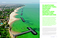
Climate Risk Overview
The Climate Risk Overview tool has been described by de Boer et al. (2022). Their paper described the basic elements in detail: the systematic global screening grid and the calculation of the number of people exposed to flooding. These aspects are summarised below. Four additional layers of the CRO, which were not described by de Boer et al. (2022), will be introduced here: the community aspect via World Bank income level and resilience, and the ecosystem aspect via mangroves and corals.
The site selection and exposure to flooding
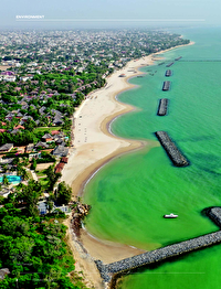
For the purpose of screening the entire planet for a combination of parameters, we start our search with the area that is at risk. This is the global Low Elevation Coastal Zone (LECZ), defined as the part of the land that is lower than 10 metres above mean sea level. We used a Digital Elevation Model (DEM) to calculate the global contour of the land 10 metres above sea level. At the sea side, we take the -50 metres depth contour to encompass all marine locations that may act as a source of sediment and could accommodate land reclamations. We used a space filling algorithm to divide the strip of land between these contours into sites of approximately 10 x 10 km2 = 100 km2. The world’s coastline was then used to split each site into wet and dry areas. For the current analyses, we kept only those sites that are at least partially covered with land. The remaining sites are irregularly shaped. The typical size of 100 km2 was chosen because it is an upper size at which communities can be informally addressed. It is also the spatial scale of local habitats, which is the typical scale at which geomorphological solutions evolve. This yielded 60,000+ sites worldwide.
The essence of the idea behind Climate Risk Overview is to combine data from a range of different sources from different disciplines for each site. We programmed a range of python modules for different data types. First, detailed grid data needs to be averaged to the sites. This is the case for global digital elevation models with a resolution of 30 m (SRTMv4, NASADEM, ALOS, MERIT), and for population data that is available at 100 m resolution (GPWv4, WorldPop). Second, coarse gridded data needs to be interpolated. Examples of this are the IPCC sea level rise projections. Third, vector data needs GIS software to calculate the overlap area. This is the case for mangrove and coral coverage patches. Also, country data is treated as vector data. Lastly, for point data sources we assigned each object to the nearest site, with a maximum distance. This is the case for the global tide and storm data sets.
Boer et al. (2022) calculated the Extreme Sea Level (ESL) for different scenarios per hotspot and combined that with the local DEM and population data to calculate the population exposed to flood risk for each site. The 2090 scenario with 1/100 year flood exposure was added to the public CRO. With this layer, sites that are prone to flooding can be detected. With the additional layers below, it is possible to filter the sites for the ecological purpose of Climate Adaptation Solutions and for the societal purpose of the Climate Adaptation Coalitions.
Communities: resilience and income level
In order to find those communities that need sustainable climate adaption solutions, we needed a compound measure to detect those sites. The most appropriate measure is the Notre Dame Global Adaptation Initiative (ND-GAIN) index (Chen et al, 2015). It is a compound measure that combines the vulnerability to climate change of a country with its readiness to improve. These two measures are based on respectively 36 detailed and 9 base indicators. The resilience is the readiness minus the vulnerability. The resulting normalised ND-GAIN is a number between 0 and 100, with a higher value being better. Most European countries have values in the range of 60-80, whereas developing countries in Africa have values in the range of 20-30.